Giving new Pensacola Bay bridge proper landing
- September 9, 2015
- / Shannon Nickinson
- / community-dashboard
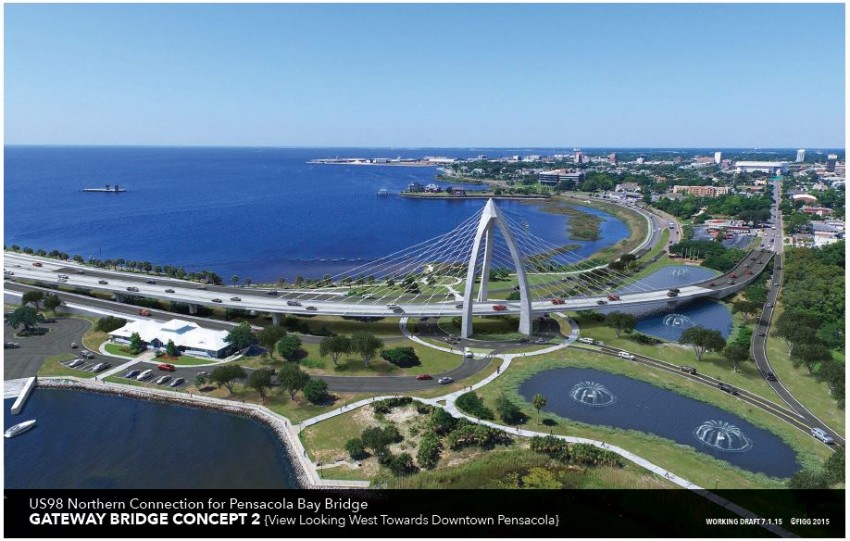
One of the proposed options for an alternative landing for the new Pensacola Bay Bridge. Photo credit: Vision Pensacola
Come 2019, there should be a new bridge across Pensacola Bay.
The $640 million project will update critical infrastructure in the community and accommodate the population growth the Studer Community Institute Metro Dashboard shows the area has seen in the last 20 years.
But what will it look like?
Plans by Florida Department of Transportation show a larger version of what is already at the intersection of 17th Avenue and Bayfront Parkway.
Vision Pensacola wants it to be more.
The citizen group has been lobbying in some form or another for two years to make the new bridge’s footprint in Pensacola something more than eight lanes of asphalt.
“This needs to be an iconic threshold for our city,” said Steve Dana, vice president of Jerry Pate Design. “What they were giving us is a bigger version of what we have. It totally destroys everything Pensacola is trying to become with reconnecting the neighborhoods to the water. This is just a larger barrier to that.”
Dana and Alan Gray, president of First City Development Group and former city planner, have been on a tour of civic groups and local governments to try to bolster support for another vision of what the intersection can be.
The key point is a roundabout for local traffic and a flyover that takes bridge traffic coming from Gulf Breeze to Gregory Street near Bagelheads.
Traffic on Bayfront Parkway going from Pensacola toward Gulf Breeze will use the new westernmost span of the planned double span, six-lane bridge.
Here is what is now on the drawing board:
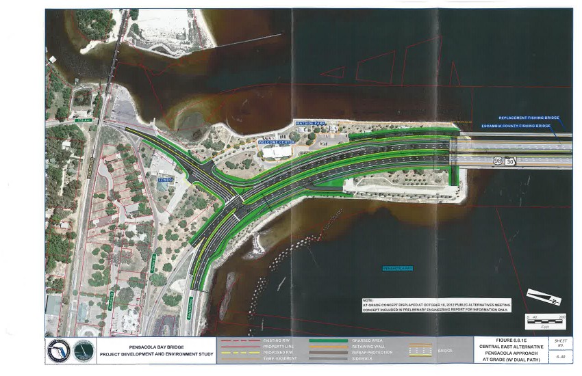
The landing proposed by Florida Department of Transportation for the new Pensacola Bay Bridge.
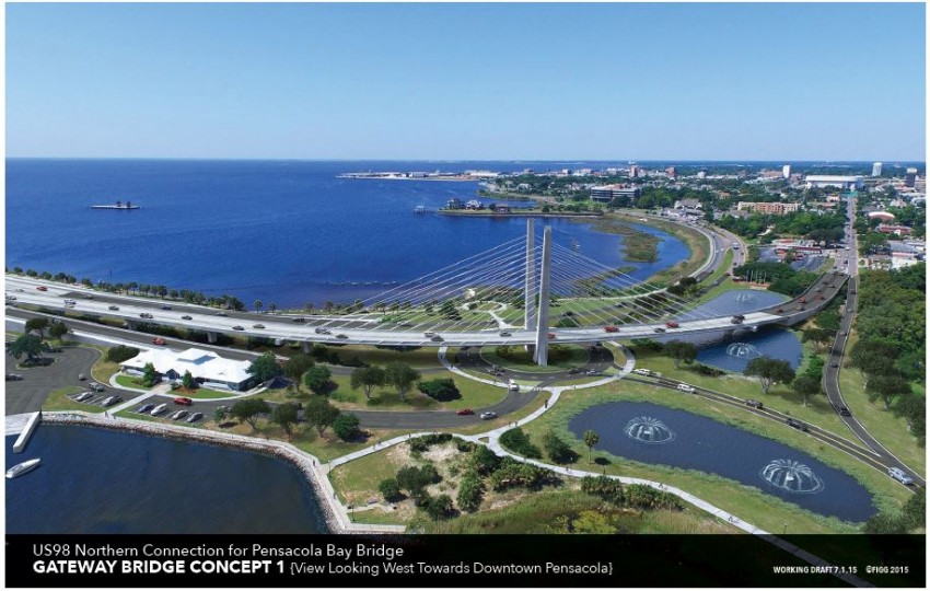
Here is what Vision Pensacola proposes:
One of the possible alternative landing designs for the new Pensacola Bay Bridge. Photo credit: Vision Pensacola.
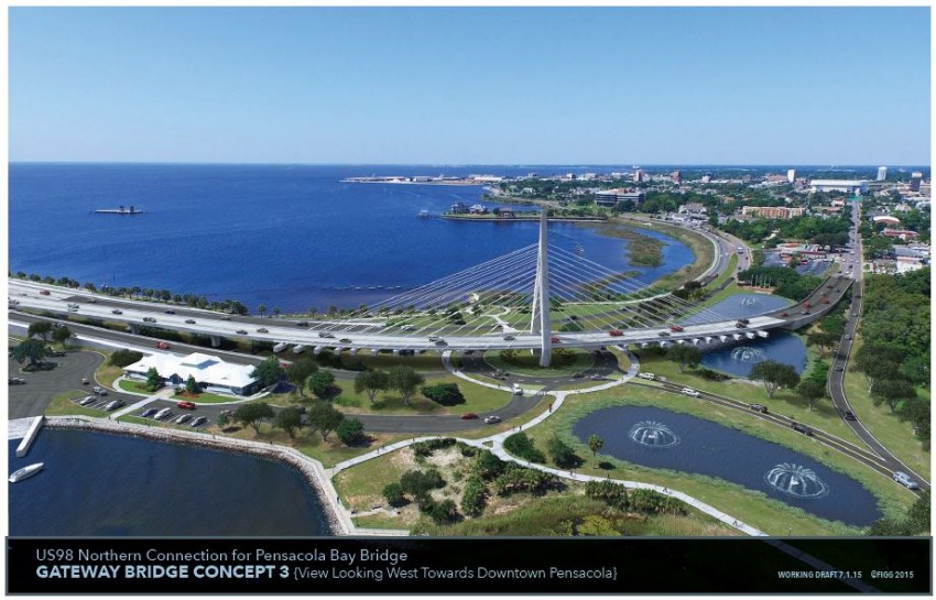
One of the possible alternative landing designs for the new Pensacola Bay Bridge. Photo credit: Vision Pensacola.
One of the possible alternative landing designs for the new Pensacola Bay Bridge. Photo credit: Vision Pensacola.
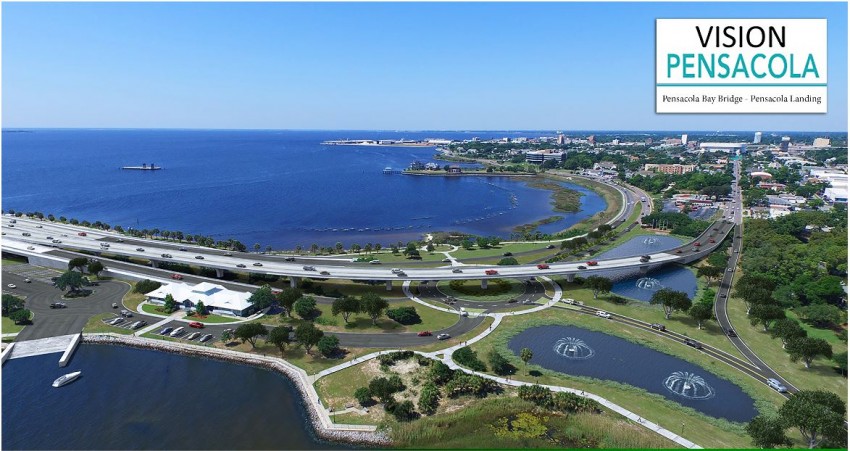
The simplest alternative design possibility for the new Pensacola Bay Bridge. Photo credit: Vision Pensacola
The Florida Fish and Wildlife Conservation Commission boat storage area will have to be relocated, but Dana says, “they want to move. They’re ready for it and they’re willing to.”
The Florida Alabama Transportation Planning Organization — which sets the priority list of road projects in a community — will meet Oct. 7, where the idea of this iconic landing for the new bridge will be ranked on the priority list.
Projects that make the list are more likely to get the green light from the state; those that don’t make the priority list don’t usually make the cut.
The Vision Pensacola group is trying to build a strong show of support to sway TPO members.
Best foot forward
Dana says his involvement in the project grew out of his time on an advisory committee for the bridge project. Dana says early on the concern was that the bridge would be a toll bridge, something the local legislative delegation, led by State Sen. Don Gaetz, fought.
Gaetz ultimately helped secure funding for the project from state transportation funds.
Dana and some others worked an alternative design for the bridge landing independent of the ongoing DOT process, which Vision Pensacola is now backing. Dana said that his company will not bid to work on the project.
They count it as progress that Florida DOT agreed to do a preliminary design and engineering study on the alternative landing project. That process, DOT spokesman Ian Satter says, will start in early 2016.
Now that the toll is dead and the money is secured for the new bridge, Dana, Gray and others on the Vision Pensacola team are pushing to make sure the new bridge’s landing gets the same consideration it would receive were it built in South or Central Florida.
Traffic count on U.S. 98 in that area now, according to DOT spokesman Ian Satter:
- The Pensacola Bay Bridge alone sees 53,000 cars a day.
— There are 16,000 cars on 17th Avenue a day.
— Bayfront Parkway sees 14,000 cars a day.
— Chase Street sees 15,000 cars a day.
— Gregory Street sees 17,000 cars a day.
“Let’s make the bridge look nice and function properly,” Gray says. “Right now the bridge has 55,000 vehicles in and out. In 2035, it will be 70,000 vehicles. That’s a lot of impressions to make. This is a gateway district of our community, a chance to put the best foot forward.”
Gray says that best foot can be put forward by dedicating 1 percent of the budget for lighting and decorative features that will make the bridge pleasing to the eye.
“The (Interstate 10) bridge to Pace is very raw engineered bridge. It doesn’t have an aesthetic quality,” Gray says. “DOT would never send a bridge like that across a waterway in South Florida or Central Florida. They wouldn’t do it. They would give them amenities like uplighting, decorative railing, because they know the community over there demands it. We just never did. And this is where West Florida is changing. We’re establishing that we have vision, just treat us with the same about of respect you treat Orlando or Fort Lauderdale.”
Alternative offers
Dana and Gray’s concerns are not only aesthetic.
“As low as a Category 2 storm has the ability to wash out some of this facility,” Gray notes. “This road bed is all gone in a storm. That’s not forward thinking.”
Dana says in a design similar to the one they propose, the northbound bridge lane stays above grade all the way to Gregory Street at elevation 22 (feet). That will meet Federal Emergency Management Agency guidelines regarding wave action and storm surge.
“Storm surge maps show Bayfront flooding,” Dana says. “(The alternative landing design allows) when the bridge is shut down before and after a storm, you can still have emergency vehicles back and forth.”
Says Gray: “Only this solution offers resiliency after a storm. If we’re going to spend half a billion dollars, let’s make sure this bridge works (after a storm).
It also treats stormwater on site in a series of lake features that can be attractive, like Admiral Mason Park, which Pate Designs worked on. It also integrates the boat ramp from 17th Avenue into Wayside Park, puts more activity in Wayside Park.
The roundabout would be for local traffic only, so there’s no need for a driver getting off 17th Avenue to stop the traffic coming off a six-lane freeway, which is what the bridge is, Gray notes.
Vision Pensacola members feel they are building a tide of support for their idea that didn’t exist a year ago. They have by resolution support from the City of Pensacola, City of Gulf Breeze, Escambia County and the Florida Alabama Transportation Planning Organization for the alternative landing.
Their Facebook page has more than 1,800 likes.
DOT says it needs to see that support to justify moving the alternative landing project forward.
“At the DOT level, to justify changing stream, they need to have that public support,” Dana says. “And so far so good; we’ve had great support.”
The bridge construction doesn’t start until 2017 and it’s a two-year project. While Gray and Dana say the alternative landing could be delivered within the $640 million projected budget for the project, DOT is indicating it would be built as a separate project.
“What they are proposing is not funded as far as the current replacement of the bay bridge,” Satter says. “The majority of those funds are programmed for bridge replacement, but we are conducting a study for the landing in that area and we’ll study several alternatives, including the one proposed by Vision Pensacola.”
“Our main concern is the replacement of that bridge and making sure that it flows well into that area,” Satter says. “We need to study the best way to do that. We’re going to have to look at a lot of different things in that study.”
That includes environmental impacts, businesses or residences that might be affected, crash data and traffic counts.
“We’ll take the guidance of locals, and we want to be good stewards of taxpayer dollars on these projects,” Satter says. “It’s a lot to work through.”
Recent Posts
-
 CivicCon launches with a look at good growth in cities
-
 Building stronger brains one baby, one parent at a time
-
 SCI debuts commercial on Early Learning City
-
 Entrecon: World class speakers and an opportunity to sharpen skills
-
 PYP Quality of Life survey 2017
-
 EntreCon Pensacola 2016: A look back
-
 Leadership tip: getting better employee takeaways
-
 Leadership tip: be interested instead of interesting
-
 Leadership tip: delivering difficult messages
-
 Brain Bags boost Arc, Early Childhood Court programs