Mapping BP projects
- September 6, 2014
- / Shannon Nickinson
- / economy
What is BP money paying for?
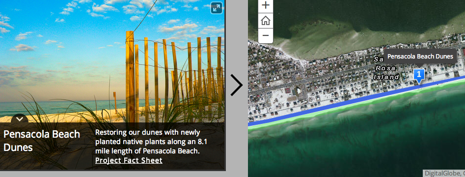
The Florida Department of Environmental Protection, along with Florida Fish and Wildlife Commission, launched a map featuring the projects that are being implemented with Deepwater Horizon oil spill funds.
Exact geographic locations, improved fact sheets and striking photos are highlights of the new map. DEP and FWC have been working collectively to implement projects across the Panhandle since the spill occurred in April 2010.
Nearly $12 million in Natural Resource Damage Assessment early restoration funds have been used for project implementation through the state of Florida. These funds stem from an agreement signed by the five Gulf states, the U.S. Department of Interior, the National Oceanic and Atmospheric Administration, the U.S. Department of Justice and BP Exploration & Production Inc. in 2011.
Some of the early restoration projects include boat-ramp enhancements that provide improved access to recreational activities such as boating and fishing in the Gulf, which are enjoyed by locals and visitors alike. The construction work on three of the four boat ramps is complete and construction on the fourth, Perdido River boat ramp, is expected to begin this fall.
An early restoration conservation project aims to restore a sea turtle nesting habitat, which was significantly disturbed during the spill-response efforts. The sea turtle habitat project will work to reduce impacts of lighting on public lands, which will benefit sea turtles’ natural navigation to the Gulf.
In addition to NRDA projects, a 2012 Deepwater Horizon settlement allowed for $10 million in funding to implement stormwater projects and land acquisitions. Several stormwater management projects have broken ground in Santa Rosa, Okaloosa and Bay counties and are improving water quality of various bays that feed into the Gulf.
One such project is a conservation easement at Escribano Point in Santa Rosa County. The shoreline provides stopover and foraging habitat for migrating shorebird species such as the Cuban snowy plover, least tern and black skimmer. It also protects the estuarine system and adjacent Blackwater Bay, which contain seagrass beds vital to fish and other marine species.
Check out the map here.
[progresspromise]
Recent Posts
-
 CivicCon launches with a look at good growth in cities
-
 Building stronger brains one baby, one parent at a time
-
 SCI debuts commercial on Early Learning City
-
 Entrecon: World class speakers and an opportunity to sharpen skills
-
 PYP Quality of Life survey 2017
-
 EntreCon Pensacola 2016: A look back
-
 Leadership tip: getting better employee takeaways
-
 Leadership tip: be interested instead of interesting
-
 Leadership tip: delivering difficult messages
-
 Brain Bags boost Arc, Early Childhood Court programs