The missing link to a flooding problem
- December 29, 2014
- / William Rabb
- / community-dashboard
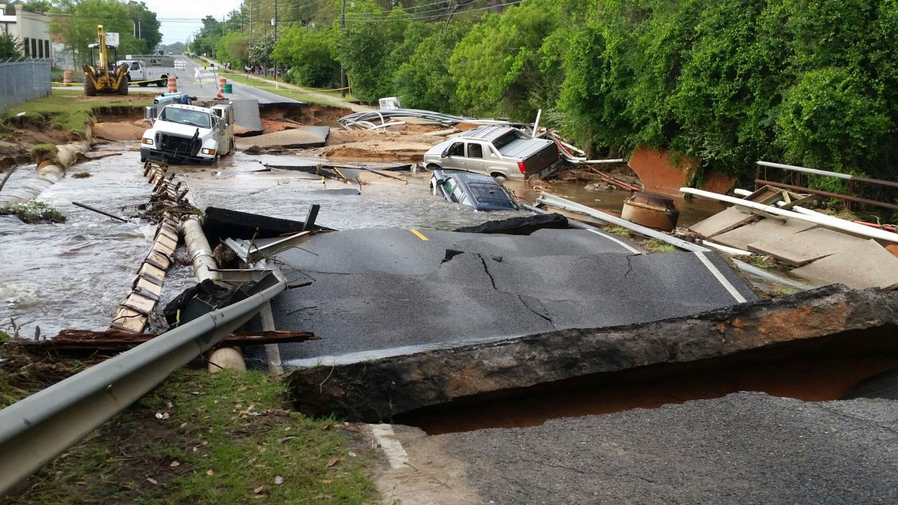
When Forest Creek Apartments flooded in April for the second time in two years, the owners started looking for a local, state or federal program that would help relocate the residents to higher ground and turn the site into a much-needed wetland or stormwater-retention area.
Nine months later, they're still looking.
“I don't think you could find a better example of a need for a public-private solution to a problem that's affected so many,” said Morgan Cox, owner of the 200-unit complex alongside Jones Creek in Warrington, just west of the Wal-Mart on Navy Boulevard.
The fact is, federal sources, from the Federal Emergency Management Agency to the U.S. Department of Housing and Urban Development, offer a number of programs that cover at least some of the cost of relocating or elevating flood-prone structures. But all of the programs carry strict requirements, and only cover property within long-existing flood zones, or which have been damaged by certain hurricanes. None of the grants cover more than 75 percent of the cost.
Regulations are often so complex that consultants are usually asked to help weed through the maze. Even that's not enough in some cases. Although he worked closely with a consultant and with county officials, Cox is still unsure exactly why FEMA rejected his apartments for its relocation program.
Now, he and county officials have slim hopes that the property will qualify under a HUD program set up just for Hurricane Isaac, which barely touched the Pensacola area. Meanwhile, Cox's private insurance this year paid part of the cost of renovating the bottom floor of Forest Creek Apartments, and residents have returned.
But they sleep with one eye on the weather.
“It's a shame because we know the flooding will happen again, and we'll have to go through all of this again,” Cox said.
A growing number of Pensacolians say it's time for a streamlined, far-reaching local program, perhaps seeded with some of the millions in expected BP oil spill penalty money (known as RESTORE funds after the acronym for the federal law that authorized the money).
A local program would go well beyond FEMA and HUD programs to move homes and businesses out of low-lying areas. Those sites could then be returned to wetland or riparian status, or converted to retention ponds or other natural areas. That, in turn, could keep some stormwater out of other areas that aren't considered flood zones but which nonetheless were slammed in the April 2014 deluge and in the June 2012 rainstorms – and likely will be again as a changing climate brings more storm events and rising seas.
“We're having these flooding problems in part because so many structures have been built in riparian zones and wetlands where they should not have been allowed,” said proponent Barbara Albrecht, a biologist and director of the Panhandle Watershed Alliance, which seeks to protect waterways across the area.
Escambia County's computer mapping software shows that about 8,100 residential and commercial structures in the unincorporated parts of the county are in the 100-year flood zones, designated by FEMA in 2006. Almost 600 properties are in wetlands, the maps show.
As envisioned by proponents, a flood-mitigation program would be three-pronged: One part would pay for the cost of acquiring flood-prone structures and restoring natural areas; another would help convert paved parking lots to pervious surfaces that would absorb runoff; and a third would pay waterfront property owners to replace seawalls with “living shorelines” made of marsh grass, oyster beds and breakwaters, where feasible.
“It sounds like a completely appropriate use of RESTORE funds, particularly for Florida's state allocation,” said Steve Murchie, campaign director for the Gulf Restoration Network, which works to restore natural areas along the Gulf Coast. “RESTORE funds count as local matching funds, too, so they could be leveraged against other federal or state pots of money such as FEMA programs.”
Like wetlands, living shorelines have been shown to dissipate the power of storm surges, provide vital habitat, and adjust to rising sea levels — unlike hardened shore structures, which can lead to further erosion on adjacent properties.
“Having people take down, especially old seawalls that are about to fail anyway, through RESTORE funding, is a great idea,” said Heather Reed, a marine biologist who runs a living shoreline and ecological restoration company in Pensacola.
Escambia County leaders in some ways have agreed with these ideas. In a recent pitch to the RESTORE Advisory Committee, which will decide how part of Escambia County's share of the oil spill money will be divvied up, Keith Wilkins, the county's director of community and environment, promoted the idea of moving flood-prone structures and replacing impervious parking lots.
About 30 percent of the vast amount of pavement around Town and Country Plaza at Pace Boulevard and Fairfield Drive, which houses county offices and retail stores, could be converted to porous surface, Wilkins told the committee in December.
“If the powers wanted to fund such a program through RESTORE, LOST (Local Option Sales Tax) or other sources, yes, there is a need,” Wilkins told PensacolaToday.com.
Pensacola leaders already have shown they can innovate programs that tap into federal funding. The inspiration for the flood-mitigation idea is Rebuild Northwest Florida, the much-acclaimed wind mitigation program that matches 25 percent of homeowner money with 75 percent from FEMA to fortify homes against hurricane winds. It's believed to be one of the few programs of its kind in the country. Work includes installing hurricane straps, storm shutters and wind-rated windows and doors. In return, participating houses receive significant discounts on homeowners' insurance premiums.
Begun after Hurricane Ivan struck the area in 2004, Rebuild this year marked its 12,000th home fortification, and has provided more than $80 million in wind-mitigation grants, officials said.
That same concept could be applied to flood and shoreline mitigation, Albrecht, Reed and others said.
A few states and counties around the United States have adopted similar flood-mitigation programs. New Jersey's Morris County may be an ideal example for the Pensacola area to emulate.
Under that program, which was greatly expanded after Hurricane Irene caused widespread flooding in 2011, the northern New Jersey county in some cases leverages FEMA funding by providing the 25 percent local match. But it also goes well beyond the FEMA programs, and will provide up to 75 percent of the total project costs (acquisition, demolition, restoration of natural area), if the city or township provides the 25 percent. The local match can come from federal or state grants, municipal coffers, or private sources.
Funding for the program comes from an “open space tax” on property. A $100,000 home, for example, pays an extra $10 a year in property taxes per year, dedicated to the Preservation Trust Fund, said Jennifer McCulloch, who manages the program for Morris County.
Since it began, the program has acquired 46 properties at a cost of $3.8 million, with 74 more properties approved for demolition in coming years.
Altogether, the program has set aside more than $16 million, which should translate to about $82 million in benefits for the community, according to a cost-benefit computer analysis done for Morris County.
The analysis shows that for every dollar spent by the program, it provides, on average, five times that in benefits for the county and taxpayers in reduced flooding damage costs to infrastructure, other residences and businesses and public property, McCulloch said.
The FEMA programs are helpful, but only for certain properties that already have flood insurance, she said. Those programs offer “a pretty wide-gauge net,” she said. “Morris County's program is the small-gauge net – if you flood, you qualify.”
So far, the program has met its goals: In April rainstorms, the cleared areas “did, in fact, soak up the floodwaters like a sponge, so it didn't spill over into neighboring land,” she said.
McCulloch offered this advice to Escambia officials considering a similar program: Hire a good manager specifically to oversee the complex program, and make the application process as streamlined as possible for residents.
The cost of a similar Pensacola-area program would depend on how extensive it would be, if it would be limited to repetitive-loss structures, or to those in wetlands, or those in designated flood zones. Escambia County's mapping system shows only 11 repetitive-loss structures, those that have had significant damage at least twice in 10 years, outside the Pensacola city limits, that are in defined wetlands. Most of those were built before local and state regulations limited building in wetland areas. About 14 properties that sustained damage in the April 2014 flooding, in unincorporated Escambia County, are in wetlands, the maps show.
But of the 432 properties outside the Pensacola city limits that have had repetitive losses, 91 percent are within the FEMA 100-year flood zones. To take it a step further, a local program could target all structures in wetlands. In unincorporated Escambia County, that number comes to more than 600, the county maps show. At a price of $90,000 each, for example, the total cost just for property acquisition would reach $54 million.
Another caveat, said Chris Bosso, a biologist who runs a wetlands consulting company in Pensacola, is that many wetlands must be maintained for years after they are restored, to correct siltation and prevent exotic plants from taking over. All of that will add to the cost. But with Escambia County expecting as much as $200 million from the penalties paid by BP and others involved in the 2010 Gulf oil disaster, funds will be available, proponents of flood-mitigation program say.
“We can do that. We can be pro-active,” said Albrecht, who is also president of the conservation-minded Bream Fishermen Association. “We can raise the bar.”
See interactive GIS maps showing April damages, as well as wetlands and flood zones:
http://escfl.maps.arcgis.com/apps/OnePane/basicviewer/index.html?appid=5e3c25fed3ee40f89476f432f60e59f8
Recent Posts
-
 CivicCon launches with a look at good growth in cities
-
 Building stronger brains one baby, one parent at a time
-
 SCI debuts commercial on Early Learning City
-
 Entrecon: World class speakers and an opportunity to sharpen skills
-
 PYP Quality of Life survey 2017
-
 EntreCon Pensacola 2016: A look back
-
 Leadership tip: getting better employee takeaways
-
 Leadership tip: be interested instead of interesting
-
 Leadership tip: delivering difficult messages
-
 Brain Bags boost Arc, Early Childhood Court programs